Holy Land: New Testament Then & Now Relief Map
2018-06-01
Publisher Description
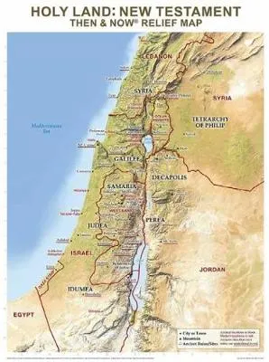
Rose Publishing's Then and Now (R) Relief Maps show the physical details of Bible places including mountains, valleys, rivers, and deserts. See where Bible places are today: red print lines show the major cities and boundaries of modern countries. This relief map focuses on the land of Israel in the New Testament time, with present-day locations overlaid in red.Printed on heavy chart paper and laminated for durability; you can use water soluble markers to write on and wipe off with ease. Includes reproducible worksheets on the back, a great reference tool for classrooms and teaching.
$24.99
$24.99
Earn
reward points per item
Click & collect: Select your store
Get information on product availability in store.
Publisher Description
Rose Publishing's Then and Now (R) Relief Maps show the physical details of Bible places including mountains, valleys, rivers, and deserts. See where Bible places are today: red print lines show the major cities and boundaries of modern countries. This relief map focuses on the land of Israel in the New Testament time, with present-day locations overlaid in red.Printed on heavy chart paper and laminated for durability; you can use water soluble markers to write on and wipe off with ease. Includes reproducible worksheets on the back, a great reference tool for classrooms and teaching.